Saturday, August 20, 2011

Land of the Thunder Dragon, Part 7: Jangothang to Bhonte La to Dangochang

We awoke the next morning to another brilliant, clear day. Our day of rest had rejuvenated both body and mind, and we were eager to tackle the biggest challenge of the trek, the pass at Bhonte La. We had been joking for a couple of days about the scene in the first Lord of the Rings film in which the Fellowship nears death on the mountain Caradhras. We knew that climbing up to a 16,000-foot (4,877-meter) pass was not going to be easy, but we were ready to give it our all.


We packed our gear quickly, being sure to have an extra dose of Diamox handy, just in case. Namgay wanted to be underway by 8:00am so that we would have plenty of time to cross the pass and get off the mountain -- we left at 7:50am, with Sonam and the rest of the crew staying behind to finish packing up camp.

We walked up toward the stone houses we'd seen the day before, crossed the Paro River -- now barely more than a stream -- and walked straight up into the bright blue sky.


The slope was steep and utterly exposed to both the wind and the sun. We found ourselves stripping off layers before we began to sweat. Heaving for breath, we understood now how the altitude and the lower air density affect one's physical condition. Namgay, of course, had no trouble and waited patiently for us as we clambered to the top of the slope.


What greeted us there was magnificent. Behind us stood Chomolhari and Jichu Drakye, gleaming in the sun.


Before us stretched a massive cirque carved by glaciers over hundreds of thousands of years. "It's like something from another planet," Jennifer said.


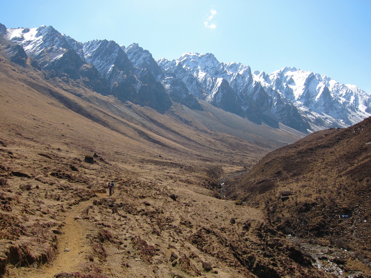
The walk up through the valley was gentle, except for the wind cascading off the mountains into our faces. Endless shades of brown, ochre, olive and umber surrounded us, punctuated by tiny, jewel-like wildflowers. Namgay explained that in the summer, the entire valley would be green and lush. We looked in vain for the Himalayan blue sheep, which is known to live in the area; all we saw were grazing yaks.


Two hours after leaving camp, we came upon two tarns at the end of the cirque. Ruddy shelducks and fat brown trout brought to Bhutan from Kashmir (where the British Raj had introduced them for sport) by King Jigme Wangchuck in the 1930s.


It was a hobbit's ideal fishing location at 14,370 feet (4,380 meters). Namgay explained that it is not only illegal to poach the king's fish, but it's also bad karma. One never knows who has been reincarnated as a fish! We rested for a while by the shore of the first lake, called Tshophu, and Patrick pocketed a small rock to send to his mother for her collection.


Leaving the lake shore, we began to climb up toward the pass.


As we walked up into the snow line, we found ourselves slipping frequently on the loose stone and scree under our feet. Patrick put away the camera and focused on walking in his slick-bottomed boots. After about 20 minutes of walking, the hill dropped off swiftly to our right in a talus slope, terminating about 250 feet (75 meters) below. The wind picked up as we walked into deeper snow. Patrick found himself slipping again and again, so he decided to try a technique he'd seen on TV. He faced the mountain, resting his weight upslope on his hiking pole, then kicked steps into the snow. The technique worked, but it was exhausting in the thin air.

At this point Sonam caught up with us, carrying his giant backpack. Sonam was an inveterate whistler -- we'd listened to him whistle the same tune for the last four days. When we heard Sonam's whistle, we knew all was well.

Sonam wasn't whistling.

The expression on Sonam's face was one we'd never seen before. He passed both of us to speak urgently -- and quietly -- with Namgay. The two of them debated for a few minutes. Namgay said, "I think we will try a little more -- maybe 20 minutes. The horseman does not want to come this way, but we will try."

For another 15 minutes, Namgay led the way and Sonam walked with Jennifer, Patrick bringing up the rear, wearily kicking steps in the snow. Then Patrick slipped. Both of his feet left the ground, and all of his weight fell onto the hiking pole. For a moment he was sure he was falling off the mountain. The pole held him long enough for him to fall on his hands and knees, and he only slid a couple of feet down the slope. No one saw him fall -- Jennifer, who is not fond of heights, was focusing with furious intensity on her own footing, while Namgay and Sonam were studying the sky above the pass. Patrick picked himself up slowly, trembling as the adrenaline hit him. His hiking pole had compressed and bent under the impact, but it held. Patrick looked down the slope and started to realize just how bad his situation could have been if he'd fallen all the way.

"Patrick, stay there!" Namgay called. Patrick looked up to see Namgay and Sonam walking back towards Jennifer. Patrick walked a few steps forward to join them. Namgay pointed up toward the pass, which lay another 90 minutes' hike above us. A dense, grey cloud was climbing over the mountain, directly atop the pass, and already we could feel the air growing colder.


"It is snowing there," Namgay said. "The horses cannot go -- they will have to go around, maybe 13 or 14 hours. I do not know how much snow there is."

We looked at each other, then at Namgay and Sonam. "Well," Patrick said, "then maybe we don't go."

"Is there another way around?" Jennifer asked.

Namgay shook his head.

"Then we have to go back the way we came?"

Namgay nodded.

The decision was easy to make. We weren't equipped for the snow, and while we were fit enough to climb the mountain in favorable conditions, our physical condition didn't give us enough strength to make up for our lack of climbing gear.

"OK," Patrick said. "Let's go back."

Gingerly shuffling our feet, we turned around on the narrow track and began to walk down the mountain. Sonam took Patrick's arm and steadied him on the slick snow. Namgay walked with Jennifer, who had finally let herself realize just how high and precarious our location was. We had almost reached the tarns when the wind hit us from behind. Then it began to snow.

At the lake shore we met the horseman and the cook, together with the mules. Perhaps it was just our imagination, but the mules seemed very happy not to be going any farther. In fact, everyone's mood was buoyant. Sonam found the skull of a blue sheep -- and then he started to whistle.


We ate lunch in the cirque, accompanied by yaks and the constant, ice-laden wind. The wind chased us all the way back out of the valley, and any doubts we might have had about our decision to turn back were quelled by the storm we could see filling the bowl of the cirque behind us. Oddly enough, despite our discomfort and disappointment, we were almost giddy with our escape. "We have to get off the mountain!" we laughed.


Around 1:00pm we reached the base camp at the foot of Chomolhari where we'd spent the last two nights. We couldn't believe we'd only been gone five hours. A flock of choughs circled overhead -- we couldn't decide if they were mocking us or welcoming us back. Namgay decided that we should press on a little farther. As we left the base camp, we passed a phallic shrine we'd somehow missed seeing on our way in.


We continued for another hour until we reached the village of Dangochang, where the school and clinic were. We wanted to press on, but Namgay insisted that we stop for the day. The wind and snow continued, but that didn't deter the schoolkids from playing soccer and shooting arrows around our campsite -- which, to be fair, was in the middle of their playground.

Sitting in the dining tent that evening, we discovered that our faces were badly chapped from windburn. Our lips and nostrils were cracked, swollen and sore. Jennifer's ankle had begun to ache again, and Patrick's back was sore from twisting it in his near-fall. Once the giddy feeling of having made it back off the mountain in one piece wore off, we began to think about the return journey. Jennifer found the thought of having to climb back over seven hours' worth of boulders deeply depressing. Patrick spoke with Namgay. "How can we break up the trip so that we don't have do all of the Day 2 trek in one day? Is there some other place we can camp?"

"Maybe there is a way," Namgay said. "We can try."

When we finally climbed into our tent that night to sleep, we couldn't stop thinking about the disaster we'd avoided walking into that morning. It was disappointing not to be able to complete the trek we'd planned, but when we realized how bad our situation could have become, we were proud of ourselves for having made smart decisions at the right moment.

That evening, Patrick recalled a passage from Michael Palin's Himalaya: "As Jomolhari fills the sky, I feel a bit like one of the characters in Close Encounters of the Third Kind when the spaceship has landed. The Himalayan peaks are seen by the people who live among them as awful places, abodes of jealous gods and places where the dead are gathered, and I have the feeling they've got it right. What do we know, we who romanticize them? We who fly in and use them to prove something to ourselves, to plant our flags, talk of 'conquest' and then go home. I can almost feel the shoulders of Jomolhari heaving with laughter. ... There are few places outside the Himalaya where the relation of man to nature can be experienced on such a gigantic scale, and something like that may not change your life, but it does stretch it a bit."

Our lives had been stretched. Thank you, Chomolhari.

Distance: 8.5? miles (13.7? km)
Altitude gain: 1,614? feet (492? meters)
Highest altitude: 15,000? feet (5,472? meters)
Final altitude: 12,959 feet (3,950 meters)
Estimated time: 6-7 hours
Actual time: 6 hours

Tuesday, May 03, 2011

Land of the Thunder Dragon, Part 6: Chomolhari Base Camp

We awoke at 5:30am to sound of ice crackling. Our breath had condensed and frozen on our sleeping bags during the night. Fortunately, neither of us had felt the need to get up and make the trek to the toilet tent during the night.


Patrick ventured out into a crystal clear morning to fetch the tea. It was cold -- 28 degrees Fahrenheit (-2 Celsius) according to his thermometer -- and terribly beautiful. A trail dog, his fur coated with a rime of ice, came over to say hello. Patrick named him "Ice Dog," and he spent most of the day at camp with us.


At the top of the valley stood Chomolhari, which rises to a summit just short of 24,000 feet (7,315 meters). It is a holy mountain, sacred to the protector goddesses (chomo) who were charged by Guru Rinpoche to uphold the Buddhist faith and protect the people who live in the shadow of the mountain. Breathtaking.


Closer at hand was a large hill. Over breakfast, Namgay -- who seemed to be feeling better -- told us that this mountain used to be much larger.


We were camped in the ancient kingdom of Jangothang, Namgay explained. The king of Jangothang, whose now ruined fortress was built to guard the valley, had commanded his subjects to cut down the mountain, because it blocked the sunlight. The people labored to fulfill the king's command, until one day a wise old woman gathered the people together. "Much easier to chop one head than a whole mountain," she told them. The people rose up and killed the king -- and thus fell the kingdom of Jangothang.

We're sure that story will prove useful for a future staff meeting.


Namgay told us we had several options for day hikes. "We can hike to the foot of Chomolhari and see the glacier," he said. "Three hours, one way. Or we can climb this mountain" -- here he pointed to another large hill beside the camp -- "and have very good views of Chomolhari and Jichu Drakye. Or--"

"Or," we said with a smile, "we could stay in camp and be lazy."


That's exactly what we did. While the day hikes sounded fascinating, we knew we could use the rest, especially with the Bhonte La pass to come. We decided to take advantage of the brilliant sunshine to air out our tent and sleeping bags -- and hoped the goddesses of the mountain didn't mind.


We took a short hike up the valley towards a set of stone houses used by yak herders and park rangers.


On our way back we ran into two young Bhutanese soldiers -- an officer and an enlisted man -- accompanied by two porters. The officer sent his subordinate and the porters ahead while he stopped to chat with us in his excellent English. He was on his way to his post at Lingzhi for a year-long assignment. The commanding officer had given him his billet and basically told him to start walking. To get to Lingzhi he and the others would have to cross the Nyile La pass at 15,978 feet (4,870 meters). Unlike us, they didn't have a mule team to carry a bunch of gear -- all they had was what was on their backs. He was quite nonchalant about it. We were most impressed, and our biggest photographic regret is not asking him for a picture before he saluted us and carried on his way.

As we got close to the campsite, Jennifer stepped badly on a stone and twisted her left ankle. It wasn't a bad sprain, but it was enough to remind us both that he had to be careful at all times. It would be a very long walk back on a broken leg, or worse.


"Now have shower," Sonam told us when we arrived back at camp. He provided us with two small bowls of "washing water" every morning. We'd already had our daily wash, so we weren't sure we understood what he meant. Then we saw that he'd moved the toilet tent to a clean part of the campsite. The cook brought out a solar shower bag and hung it in was what now the shower tent. A hot shower at 13,000 feet (4,000 meters) -- what a luxury!


After a shower and a hot lunch we had a nap in our freshly aired tent. Everyone seemed to enjoy the break -- even Ice Dog had a bit of a kip in the warm sun.


In the mid-afternoon we took him with us to explore the ruins of the dzong.


Like Rimpung Dzong, this dzong was probably built in the 1600s, when Bhutan and Tibet were at war. It had the inward sloping walls common to Bhutanese fortresses -- a feature that made it not only structurally stable, but also created a useful optical illusion of fearsome height. The fortress had a strategic position over a tributary of the Paro River and commanded a complete view of the valley. Although the dzong lay in ruins, the central tower (utse) still stood. The precision of the masonry work was remarkable, even after more than four centuries since its construction.


As we climbed over the ruins, Patrick flushed out a blood pheasant, which shrieked and dashed through the underbrush right in front of Jennifer. Ice Dog failed to catch it for our dinner.


We knew we'd be headed deeper -- and higher -- into the mountains in the morning. Patrick did his best to scout the way.


By this time we'd realized that the hours between 4:00pm and 8:00pm were the hardest to fill. The wind and clouds always seemed to move in by mid-afternoon, and once the sun dropped behind the mountains the temperature dropped with it. We retreated again to the dining tent and took turns reading to each other from Eric Weiner's The Geography of Bliss. Much to our pleasant surprise, Sonam came in with a plate of warm cashews! This was the ideal moment for Patrick to break out his 40th birthday present from Jennifer: a steel-and-leather travel bar, eminently suitable for the gentleman adventurer (and his distaff counterpart). He mixed a couple of small gin martinis, and we enjoyed a charming cocktail hour.


Just before dinner we encountered an uninvited guest just outside the dining tent, where we were sorting our gear for our departure the next day.


Soon it was time to climb back into our sleeping bags. The rest day had been good for both body and mind, and we felt ready to tackle the challenges of the next day. If only we had known how difficult those challenges would be....

Distance: 0 (rest day)
Altitude gain:
0 (rest day)

Final altitude:
13,386 feet (4,080 meters)

Monday, May 02, 2011

Land of the Thunder Dragon, Part 5: Thangthangka to Jangothang (Chomolhari Base Camp)

When we were preparing for our trek, Patrick had decided to buy two expedition-quality sleeping bags, the Marmot Trestles 0. This bag is rated to 0 degrees Fahrenheit (-18 Celsius), which seemed like too much bag for a trek with expected lows around 40-45 F (4-7 C). However, Patrick knew that Jennifer gets cold easily, and he reckoned that it would be easier for him to unzip the bag and cool off than it would be to pile on more clothes in a lighter bag.

Thanks to these big, heavy, warm bags (and the mules who carried them for us!), we slept very well despite the cold, wind and snow. We emerged from our tent at 6:00am into a fantasy realm of ice.


The small green tent next to ours was the toilet tent -- a nylon shell propped over a hole dug into the ground. We had a love/hate relationship with the toilet tent. It wasn't the most pleasant place to spend time, but being out of the wind and snow while vulnerable (if you will) was a real comfort.


We were outrageously stiff and sore from the previous day's hike. Patrick's stomach cramps had quieted down, but he decided to eat only small amounts of very plain food -- mostly rice and bread. Jennifer's left ankle, which she'd sprained badly several times over the years, had begun to ache. Still, we felt much better than we'd expected 12 hours earlier.


We saw that we had been sharing the campsite with the European group we'd seen the day before. Namgay, who was starting to fight a cold, seemed determined to beat them to the next campsite. We packed quickly and proceeded on.


The morning was beautiful, and as soon as the sun came out it began to melt the snow. Our pace was quick, but that didn't stop various trail dogs from accompanying us. Whenever we reached the limit of their territory, they'd stop and pass us on to the next dog.


We also passed two small military encampments a stone's throw apart. The first belonged to the Bhutanese Army; the second, to the Indian Military Training Team (IMTRAT). The Bhutanese Army is trained and equipped entirely by India. An Indian officer came out to greet Namgay and ask him who we were and where we were headed. Patrick surprised him and Namgay by answering the officer's questions in his limited Hindi.

The scenery was spectacular, especially once we started to rise above the treeline. We walked through meadows flanked by massive mountains; later in the spring these meadows would be filled with wildflowers. Yaks grazed on the hills, and we saw a few stone cabins used by roaming yak herders.


About halfway through our morning, we met a group of American trekkers who were headed back the way we came. They had planned to do the same trek we had, but were turned back at the mountain pass at Bhonte La. "Too much snow," one of them said. "We heard there could be as much as six to eight inches up there. But who knows -- maybe it'll all be melted away in a couple of days." They were all outfitted with expensive gear: expedition-grade jackets, deluxe trekking poles, snow gaiters, and sturdy mountaineering boots. We were a little worried that the weather had turned them back -- what would it mean for us?


Namgay's cold got worse through the day, so it was left to the indefatigable Sonam to keep up the pace. We passed through a village -- really just three or four small stone buildings -- that included a clinic and school for the families of the yak herders in the area.


Before we realized how far we'd come, we arrived at the ruined dzong of Jangothang. Alpine choughs flew up to greet us, and behind the fortress lurked the sacred mountain Chomolhari. It was 1:00pm.


We couldn't understand why we'd raced through the morning -- after less than five hours of hiking, we were at our next camp. We did seem to secure the best campsite: isolated, next to the river, and out of the worst of the wind. We set up our tent, treated some sore spots, and decided to have a look around.


An archery contest was going on in the midst of snow flurries and a constant 20-mile-per-hour (32 kph) wind. Later Namgay told us that these were local families who had come to the base of Chomolhari to have a small, week-long festival -- we'd just caught the last couple of days. Two guys from another trekking crew had also come over to watch.


Archery (datse) is the national sport of Bhutan. Traditionally archers used bows and arrows made from bamboo; today they import aluminum gear from the U.S. The field is 460 feet (140 meters) long, and the target is only about 30 inches (76 centimeters) tall and 10 inches (25 centimeters) wide. We were stunned to see these young men hitting the target despite the spiraling winds coming off the mountains. Whenever one scored a hit, the others would shout and yelp -- and often our trekking crew back at the campsite would echo them.


We were even more stunned when we realized they were drunk. Archery contests and alcohol go hand-in-hand in Bhutan. While one competitor takes aim, the others shout insults and jokes at him to spoil his concentration. Anything short of physical contact is fair game. As Michael Palin writes in his brilliant book, Himalaya, "I suppose that's the ultimate macho achievement: to be able to drink yourself silly and deliver a bull's eye while being told by your opponents that they've been shagging your wife for the last three weeks."


The cold eventually crept into all of the layers we had on and we retreated to the dining tent. We hadn't seen Namgay since we'd arrived, but we could hear him coughing and sneezing in the kitchen tent. We began to wonder if his cold had pushed him to get us to camp so quickly; we also wondered if he'd be well enough to keep going. Sonam brought us a thermos of hot water, freshly boiled from the river. We never knew the life-affirming properties of a cup of tea at 13,000 feet (4,000 meters)!


Every resource we'd found recommended that our sleeping elevation should not increase by more than 1,000-1,500 feet (305-450 meters) per night, and that for every 3,000-foot (915-meter) increase, we should spend a second night at the same elevation. In fact, the National Institutes of Health recommend stopping for a day or two of rest for each 2,000 feet (610 meters) above 8,000 feet (2,438 meters). "Climb high, sleep low."

The day before we'd gained almost 2,500 feet (760 meters) -- twice the recommended amount -- and we had ascended another 1,575 feet (480 meters) on this day. We were now at 13,386 feet (4,080 meters), and our combined total from the first three days of the trek was 5,253 feet (1,600 meters). We were well overdue for a rest day to acclimate.

At this point we were taking 500 mg of Diamox per day. We were thankful to have the medication with us, but we were starting to feel the side effects. Tingling in the extremities is common, as is more frequent urination. As we huddled in the dining tent that evening, we contemplated clambering out of our sleeping bags at 2:00am to brace the wind, hop over a ditch and squat in the toilet tent. "OK," Jennifer said, "no more water after 6:00pm."


Snow flurries and clouds thickened around our campsite as the sun set. We knew we were in for our coldest night yet, so we dressed in thermals before climbing into our sleeping bags. We tried to relax -- tomorrow was a rest day. We just hoped we wouldn't be visiting the toilet tent before dawn.


Distance: 11.8 miles (19 km)
Altitude gain:
1,575 feet (480 meters)

Final altitude:
13,386 feet (4,080 meters)

Estimated time:
5-6 hours

Actual time:
4.5 hours
Creative Commons License
The Wilson Odyssey by http://wilsonodyssey.blogspot.com is licensed under a Creative Commons Attribution-NonCommercial-NoDerivs 3.0 United States License.